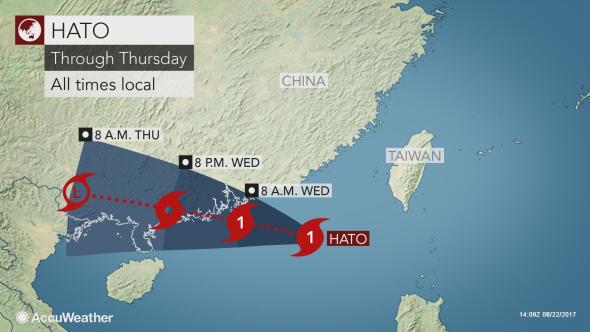
Typhoon Signal no. 10, the highest in Hong Kong's storm warning system was issued on Wednesday morning, August 23 before it was downgraded to No. 8, as Typhoon Hato battered the city.
The No. 10 signal was the 15th of Hong Kong since 1946, it was last issued on July 2012 for Typhoon Vicente.
"Tides are currently running about 0.5 metres above normal," the Observatory said in its 6.45am storm update. "The high tide, occurring before noon, and the storm surge induced by Hato may cause a rise in sea levels of about 1 metre or more above normal tide levels. There could be serious flooding in some low-lying areas."
More than 400 flights were already cancelled, financial markets suspended and schools closed as Typhoon Hato bore down on the city. Other transport services like ferries were also suspended.
"I've never seen one like this," said Garrett Quigley, a longtime resident of Lantau island to the west of the city, as reported by Reuters. "Cars are half submerged and roads are impassable with flooding and huge trees down. It's crazy."
According to a report, maximum wind near Typhoon Hato's center were recorded to be destructive at 155 km/h.
A senior officer from the Hong Kong observatory said that the sea levels could still rise at five meters in some places.
The government is reported to be issuing flood alerts already and opening 27 temporary shelters across the city.